Bridge inspection · Early access
Bridge inspection software that drafts the ratings and report for you.
Photograph the deck, superstructure, substructure and channel. Inspectial's AI drafts element condition states, suggested NBI component ratings and defect notes, each linked to the photos behind it. Your team leader approves every value, and the data goes to your bridge management system, not just into a PDF.
Capture offline under the bridge. AI drafts the condition data. The team leader approves. Export the data and the report.
- Works offline
- Every finding linked to its photo
- The team leader approves
- CSV, GeoJSON, PDF, API
Every bridge photo becomes a coded record your team leader can review.
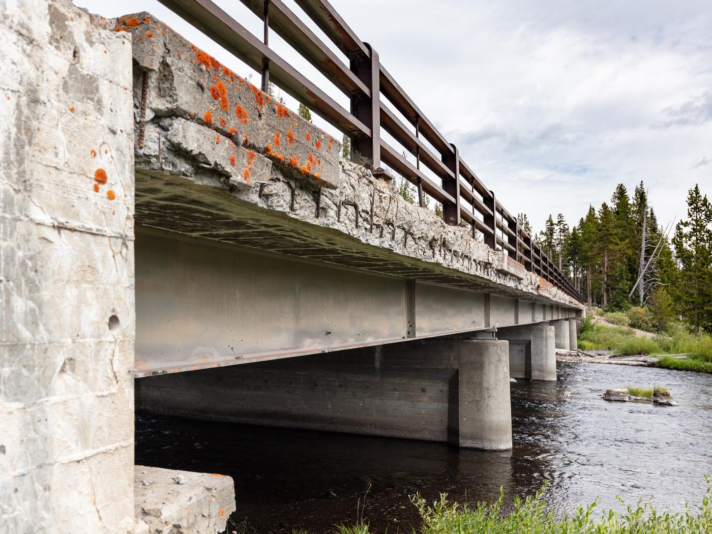
- Deck · spallingexposed rebar, CS3AI suggested
- Railing · conditionno defects visibleHuman verified
- Girder · corrosionbottom flange, CS2AI suggested
- Bearing · corrosionsurface rust (possible)AI suggested
- Pier · crackingnone visibleHuman verified
- Channel · debrisdrift logs at bankHuman verified
{
  "asset": "B-2207",
  "location": { "lat": 45.5412, "lon": -111.2386 },
  "deck": {
    "spalling": "exposed rebar, CS3",
    "status": "ai_suggested"
  },
  "railing": {
    "condition": "no defects visible",
    "status": "human_verified"
  },
  "girder": {
    "corrosion": "bottom flange, CS2",
    "status": "ai_suggested"
  },
  "bearing": {
    "corrosion": "surface rust (possible)",
    "status": "ai_suggested"
  },
  "pier": {
    "cracking": "none visible",
    "status": "human_verified"
  },
  "channel": {
    "debris": "drift logs at bank",
    "status": "human_verified"
  },
  "evidence": ["IMG_6114", "IMG_6117"],
  "confidence": 0.88
}
The inspection ends at the bridge. The write-up doesn't.
A routine bridge inspection comes back as hundreds of photos, field notes, sketches and measurements. Someone then sorts them by element, assigns condition states, codes the component ratings, writes the narrative and builds the report for the owner.
For a firm running a county's inspection program, that write-up repeats for every structure on the inspection cycle, and the SNBI adds items to collect. The report goes out as a PDF, and the condition data is re-keyed into the bridge management system.
- Photosevery element, above and below
- Field notesvoice, paper or tablet
- Measurementsspalls, section loss, clearances
- The previous reportthe baseline to compare against
How it works
One workflow from the site visit to your asset system. AI does the coding; people make the call.
-
Capture offline, element by element
The field app lists today's bridges and walks the team through deck, superstructure, bearings and joints, substructure, channel and approaches. Every photo, clip and voice note is stamped with time, GPS, structure number and element. No signal needed under the deck.
-
AI drafts the condition data
Evidence is grouped by element and turned into draft observations: the defect, a suggested condition state and component rating, a confidence and the photos it came from. Where the photos don't show enough, the AI marks it not assessable instead of guessing.
-
The team leader approves
The team leader reviews each finding next to its photos and approves, edits or rejects it. The AI's draft is kept separately from the approved value, so you can always see what a person changed. Only approved inspections become official.
-
Export to your bridge management system
Approved inspections go out as CSV or GeoJSON keyed to your structure numbers, for import into AASHTOWare Bridge Management, your state's system or your GIS. The PDF report is rendered from the same approved data, and the REST API serves it too.
What the bridge pack records
Element-level observations grouped by NBI component, the four condition states from the AASHTO Manual for Bridge Element Inspection, and suggested 0–9 component ratings for the team leader to confirm. In early access we map the template to your agency's elements, defects and report format.
Deck and wearing surface
Superstructure
Bearings, joints and railings
Substructure and channel
Condition scale
- CS1 Good
- No defects, or insignificant ones such as hairline or sealed cracks.
- CS2 Fair
- Minor defects: freckled rust, small spalls, exposed rebar without measurable section loss.
- CS3 Poor
- Moderate defects: larger spalls, measurable section loss, pack rust. No structural review needed.
- CS4 Severe
- The defect warrants a structural review, or a review found strength or serviceability affected.
Reference standards
Capture in the field. Review from any desk.
Field app preview: a map of today's route with markers by inspection status, working offline, with B-2218 selected and ready to inspect. Web app preview: the County bridges 2026 project on a map, with geotagged field photos pinned at each site and a sidebar listing each site's review status.
AI creates the inspection record, not just the report
Keep your GIS and asset system. Inspectial automates the inspection-coding layer in front of it, under rules you can trust.
- Agent-ready data, not documents
- The structured dataset is the source of truth, so your GIS, scripts and AI agents read it directly. Reports are generated from approved observations, never written straight from the media.
- Evidence first
- Every observation references the photos, clips or notes behind it. A finding never exists only as an AI sentence.
- A human approves
- AI proposes; a qualified person decides. Inspectial is not an autonomous inspector, and only approved inspections become official records. Every value is tagged with who stands behind it.
- Location is first-class
- Evidence, observations and assets carry coordinates, so the output drops onto a map without cleanup.
- Offline-first
- The full capture flow works with no signal. Data syncs when the connection returns.
- Configurable, not custom-built
- Your checklist, condition codes and report format live in a template we set up with you. Not a new app.
Who it's for
Outputs and integrations
Inspectial feeds the tools you already run. It doesn't ask you to move your asset data anywhere, and because the output is structured, evidence-linked data rather than a document, it also works as input for AI agents and automations.
Works with
- ArcGIS
- QGIS
- PostGIS
- MapLibre
Formats
- GeoJSON
- CSV
- REST API
- Excelplanned
- Shapefileplanned
- GeoPackageplanned
Questions
Something else? Write to pilot@inspectial.com.
Does the AI replace the bridge inspector?
No. Inspectial drafts observations from the evidence your team captures; it doesn't inspect anything. The team leader still leads the inspection on site and approves, edits or rejects every finding. Only approved inspections become official, and every value shows whether a person verified it.
Can it code NBI/SNBI ratings and element condition states?
The bridge template is built around element-level inspection: AASHTO elements, defects and condition states 1 to 4, plus suggested 0–9 ratings for deck, superstructure, substructure and culvert. The AI's values are drafts for the team leader to confirm. In early access we map the template to your state's elements, SNBI items and report format.
Does a phone app change hands-on or arm's-length requirements?
No. Inspectial changes how findings are recorded, not how the bridge is inspected. Hands-on means within arm's length of the member, and your team still does that work wherever your procedures require it. The app captures what they see, measure and say while they do it.
What about fracture-critical members (NSTMs)?
The 2022 NBIS calls them nonredundant steel tension members and requires a hands-on inspection, led by a team leader with FHWA-approved NSTM training. Findings on NSTMs are recorded like any other element, with their photos and the team leader's approval. Inspectial doesn't change who inspects them or how.
Does the field app work offline under a bridge?
Yes. The full capture flow works without signal: under the deck, in a creek bed or on a rural road. Photos, clips and notes stay on the phone and sync when the connection returns.
How does the data get into our bridge management system?
Approved inspections export as CSV or GeoJSON keyed to your structure numbers, or through the REST API. You import them into AASHTOWare Bridge Management, your state's system or your GIS. There's no native connector yet, so in early access we match the export columns to the fields you import.
Can we use our past inspections?
Yes, that's how early access starts. Bring photos and the reports your team wrote from them, and we compare the AI's drafts with your coded findings before anyone uses it on a live inspection.
What does it cost?
Pricing isn't published yet. Early-access teams work with us directly while we build the bridge pack, and we'll discuss pricing with you before the first release.
Request early access to the bridge pack
We're onboarding a few bridge inspection teams to shape the bridge template. Tell us what you inspect, roughly how many bridges a year, and which bridge management or GIS system you report into.
- Bring past inspections: photos and the reports your team wrote from them.
- We set up a bridge template that matches your elements, defect codes and report format.
- Your team leaders review the AI's drafts against their own coded findings.
- Exports arrive as CSV, GeoJSON or PDF, or through the API, in the layout you import.