MS4 stormwater inspection · Early access
Stormwater inspection software that drafts every BMP and outfall record for you.
Photograph the pond, rain garden or outfall and talk through what you see. Inspectial's AI drafts a structured record from your photos and voice notes: BMP condition, maintenance needs, dry-weather flow and outfall indicators, located and keyed to your asset ID. Your inspector approves every finding, and the data lands in your GIS, not in a binder.
Capture offline. AI drafts each finding. An inspector approves. Export to ArcGIS, QGIS or your MS4 tracking system.
- Works offline
- Every finding linked to its photo
- A qualified reviewer approves
- GeoJSON, CSV, PDF, API
Every outfall and BMP photo becomes a record your team can review.
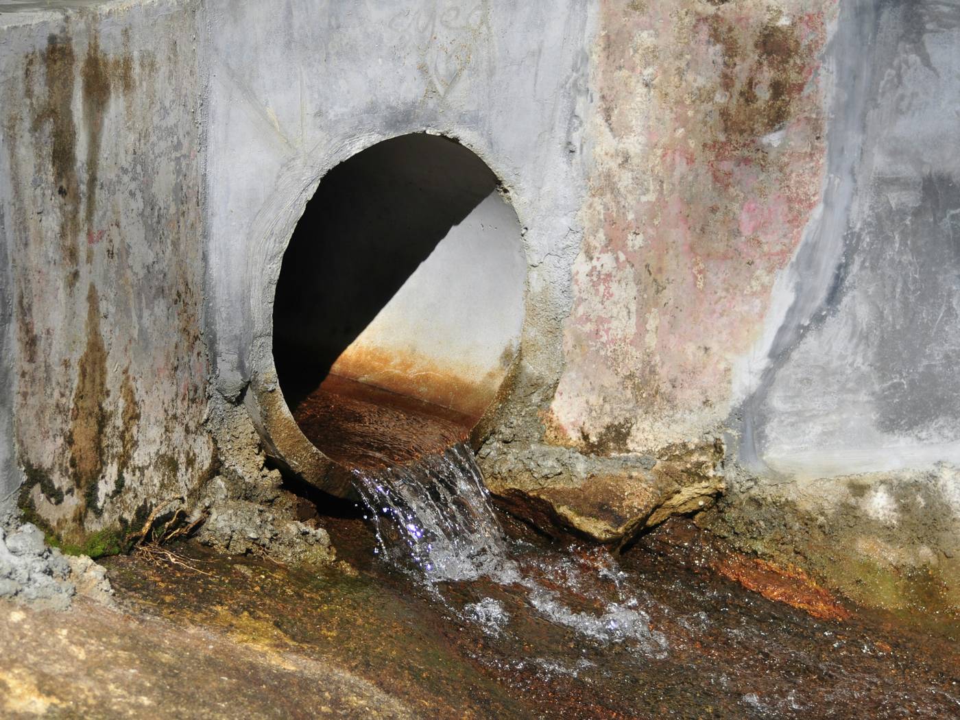
- Outfall · openingunobstructedHuman verified
- Outfall · flowpresent, clearHuman verified
- Pipe invert · depositsrust-orange stainingAI suggested
- Headwall · stainingrust-colored streaksAI suggested
- Headwall · structurebroken concrete at outletAI suggested
- Channel · depositsorange deposits (possible)AI suggested
{
  "asset": "OF-118",
  "location": { "lat": 38.9586, "lon": -77.357 },
  "outfall": {
    "opening": "unobstructed",
    "flow": "present, clear",
    "status": "human_verified"
  },
  "pipe_invert": {
    "deposits": "rust-orange staining",
    "status": "ai_suggested"
  },
  "headwall": {
    "staining": "rust-colored streaks",
    "structure": "broken concrete at outlet",
    "status": "ai_suggested"
  },
  "channel": {
    "deposits": "orange deposits (possible)",
    "status": "ai_suggested"
  },
  "evidence": ["IMG_2207", "IMG_2208", "VOICE_014"],
  "confidence": 0.86
}Hundreds of BMPs and outfalls per permit cycle. Every one gets re-keyed.
Each pond, rain garden or outfall comes back as photos on a phone, a form and a few notes. Someone in the office then matches it to the asset ID, completes the inspection form, lists the maintenance items, updates the GIS and adds it to the count for the annual report.
Multiply that by every BMP and outfall in the inventory, and a small stormwater team spends more of the permit cycle re-keying field data than inspecting.
- Photosinlet, basin, outlet, outfall
- Inspection formspond, bioretention, swale, outfall
- Voice and text notesflow, color, odor, maintenance
- GPS and the asset inventoryin separate places
How it works
One workflow from the BMP or outfall to your GIS. AI drafts the findings; your inspector makes the call.
-
Capture offline, asset by asset
The field app lists today's BMPs and outfalls by distance and walks the inspector through the checklist for each asset type: inlet, basin, outlet and embankment for a pond; flow and visible indicators for an outfall. Every photo and voice note is stamped with time, GPS and asset ID. No signal needed.
-
AI drafts the findings
Evidence is grouped by component and turned into observations: sediment, clogging, standing water, erosion, vegetation, trash and structural damage, and at outfalls flow, color, turbidity, floatables, deposits and stains. Each has a severity, a confidence and the photos it came from.
-
An inspector approves
A qualified inspector checks each finding next to its photos and approves, edits or rejects it. The AI's draft is kept apart from the approved value, so you can always see what a person changed.
-
Export to your GIS
Approved inspections go out as GeoJSON, CSV, a PDF report or through the API, keyed to your asset IDs, with inspection date and condition ready to join to your ArcGIS or QGIS layers.
What the stormwater pack records
Four asset groups, the outfall indicators used in dry-weather screening, and a four-step maintenance scale. In early access we map it to your permit's inspection forms, SOPs and asset IDs.
Outfalls and dry-weather screening
Bioretention and green infrastructure
Ponds and basins
Inlets, swales and conveyance
Maintenance scale
- No action
- Functions as designed. Nothing to fix before the next routine inspection.
- Maintenance needed
- Routine work: remove sediment or trash, mow, replace mulch, clear an inlet. Schedule it.
- Repair needed
- A component is damaged or not working: eroded embankment, broken outlet structure, clogged media. Repair and reinspect.
- Failed
- The practice no longer treats or controls runoff, or there's a safety risk. Act now.
Reference standards
Capture in the field. Review from any desk.
Field app preview: a map of today's route with markers by inspection status, working offline, with BMP-042 selected and ready to inspect. Web app preview: the 2026 MS4 inspections project on a map, with geotagged field photos pinned at each site and a sidebar listing each site's review status.
AI creates the inspection record, not just the report
Keep your GIS and asset system. Inspectial automates the inspection-coding layer in front of it, under rules you can trust.
- Agent-ready data, not documents
- The structured dataset is the source of truth, so your GIS, scripts and AI agents read it directly. Reports are generated from approved observations, never written straight from the media.
- Evidence first
- Every observation references the photos, clips or notes behind it. A finding never exists only as an AI sentence.
- A human approves
- AI proposes; a qualified person decides. Inspectial is not an autonomous inspector, and only approved inspections become official records. Every value is tagged with who stands behind it.
- Location is first-class
- Evidence, observations and assets carry coordinates, so the output drops onto a map without cleanup.
- Offline-first
- The full capture flow works with no signal. Data syncs when the connection returns.
- Configurable, not custom-built
- Your checklist, condition codes and report format live in a template we set up with you. Not a new app.
Who it's for
Outputs and integrations
Inspectial feeds the tools you already run. It doesn't ask you to move your asset data anywhere, and because the output is structured, evidence-linked data rather than a document, it also works as input for AI agents and automations.
Works with
- ArcGIS
- QGIS
- PostGIS
- MapLibre
Formats
- GeoJSON
- CSV
- REST API
- Excelplanned
- Shapefileplanned
- GeoPackageplanned
Questions
Something else? Write to pilot@inspectial.com.
Does the AI replace the stormwater inspector?
No. AI drafts the observations; a qualified inspector approves, edits or rejects each one. Only approved inspections become official records, and every value shows whether a person verified it. Judgment and sign-off stay with your staff.
Can it follow our permit's inspection forms and SOPs?
Yes. The stormwater pack is a template: asset types, checklist items, outfall indicators and the maintenance scale are configuration, not code. In early access we set it up from your current pond, bioretention, swale and outfall forms and your asset IDs. Your permit and your program decide what gets recorded; Inspectial doesn't decide compliance.
How does it handle dry-weather outfall screening?
The outfall checklist records whether flow is present and the visible indicators: color, turbidity, floatables, oil sheen, deposits and stains, abnormal vegetation and structural damage. Odor and field-kit readings can't be seen in a photo, so the inspector enters them. The AI flags suspect indicators for review; it doesn't decide whether a discharge is illicit.
Does it use our GIS asset IDs?
Yes. Every inspection is keyed to your existing BMP or outfall ID and carries coordinates. Approved records export as GeoJSON or CSV, or through the REST API, so ArcGIS, QGIS and PostGIS can join them to your inventory layers. There's no native ArcGIS connector yet.
Will it write our MS4 annual report?
No, Inspectial doesn't generate the annual report. It gives you approved inspection data (asset, date, condition, maintenance needs) as CSV or GeoJSON, so counting the BMPs inspected and outfalls screened is a filter, not a hunt through folders.
Does the field app work without signal?
Yes. The full capture flow works offline, at a pond behind a subdivision or an outfall at the bottom of a ravine. Photos, voice notes and GPS sync when the connection returns.
Are the photos usable as documentation?
Every observation links to the photos and notes behind it, stamped with time, GPS and asset ID, and the record shows who approved each value. That gives you a clear trail for the inspection records your permit asks you to keep. What counts as sufficient documentation is set by your permit, not by us.
Is this for construction site inspections too?
No. This pack covers the inspections an MS4 runs on its own inventory: post-construction BMPs, outfalls, inlets and ponds. For weekly and post-storm inspections on active construction sites, see the SWPPP inspection pack.
Request early access to the stormwater pack
We're opening the MS4 stormwater pack to a small number of permittees and consultants. Tell us what you inspect, roughly how many BMPs and outfalls a year, and which GIS or asset system you report into.
- Bring past inspections: photos and the forms you filled in from them.
- We set up a template from your BMP and outfall forms and asset IDs.
- You compare the AI's drafts with your inspectors' findings.
- Approved data arrives as GeoJSON, CSV or PDF, or through the API.