Lead service line inventory · Early access
Resolve unknown lead service lines with evidence-linked inventory records.
Inspectial guides the field tech through the evidence each visit needs: the pipe at the curb stop or meter, the entry into the building, and the scratch and magnet tests. AI drafts the material for the utility-owned and customer-owned portions, with a confidence score and the photo behind every value. A qualified person approves each classification before it reaches your inventory.
Capture offline. AI drafts the material. A qualified person approves. Export keyed to your service IDs.
- Works offline in pits and basements
- Every value linked to its photo
- A qualified person approves
- GeoJSON, CSV, PDF, API
Every service line visit becomes a record your reviewer can check.
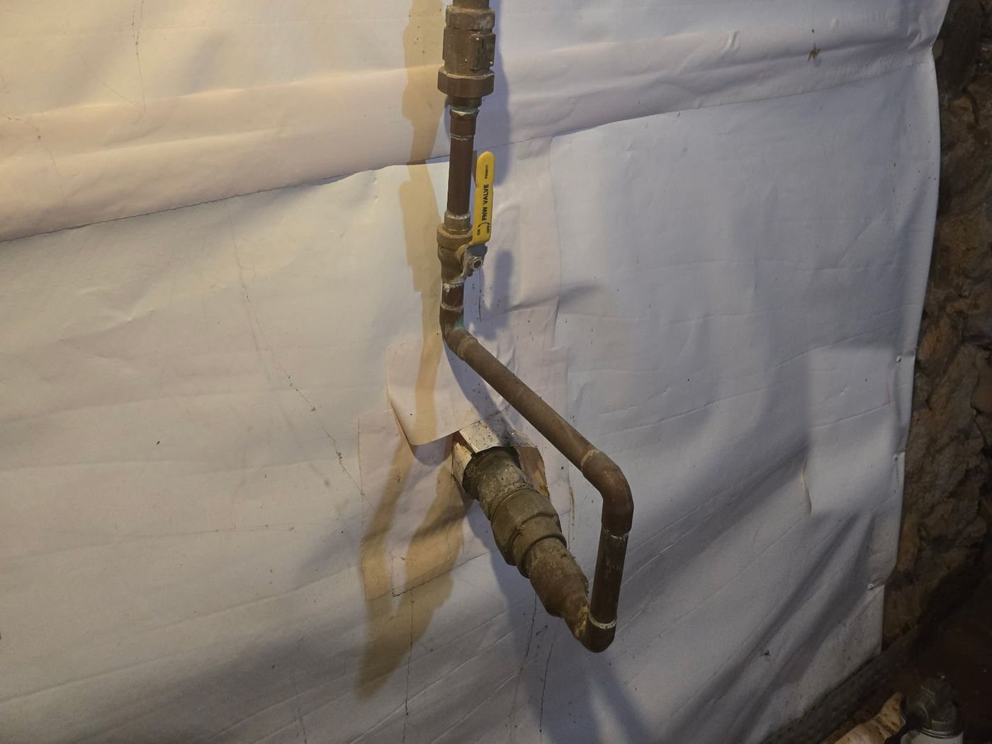
- Service line · material at entrygalvanized (possible)AI suggested
- Service line · fitting at entrybrass couplingAI suggested
- Building piping · materialcopperHuman verified
- Building piping · jointssolderedHuman verified
- Shutoff valve · typeball valve, first after entryAI suggested
{
  "asset": "SL-2214",
  "location": { "lat": 41.0812, "lon": -85.1386 },
  "service_line": {
    "material_at_entry": "galvanized (possible)",
    "fitting_at_entry": "brass coupling",
    "status": "ai_suggested"
  },
  "building_piping": {
    "material": "copper",
    "joints": "soldered",
    "status": "human_verified"
  },
  "shutoff_valve": {
    "type": "ball valve, first after entry",
    "status": "ai_suggested"
  },
  "evidence": ["IMG_5310", "IMG_5311", "VN_0412"],
  "confidence": 0.64
}
The visit takes minutes. The inventory update doesn't.
Each verification comes back as photos of the pipe at the curb stop, meter pit or building entry, a scratch test, a magnet test and a note about what the tech saw. Someone in the office then matches it to the service address, decides the material for each side, keys it into the inventory spreadsheet and updates the GIS.
Initial inventories reported more than 23 million US service lines as lead status unknown, and every one of them has to be resolved. Photos that miss one side of the curb stop, or never show the test, send a crew back out.
- Photoscurb stop, meter pit, building entry
- Test resultsscratch and magnet, in a note
- Recordstap cards, build year, permits
- Address and service IDin a separate spreadsheet
How it works
One workflow from the curb box to your inventory. AI drafts the record; qualified people make the call.
-
Capture offline, address by address
The field app lists today's service lines by distance and walks the tech through your checklist: the curb stop or meter pit, both sides of the curb stop where they can be reached, the pipe at building entry, and the scratch and magnet tests. Every photo and voice note is stamped with time, GPS and service ID. No signal needed.
-
AI drafts the material for each side
Evidence is grouped by portion and turned into a draft: material for the utility-owned and customer-owned sides, connector and fittings, each with a confidence and the photos it came from. Test results come from the tech, not from the AI.
-
A qualified person approves
A reviewer checks every value next to its photos and approves, edits or rejects it. Unclear evidence stays lead status unknown until someone with the authority to classify it decides. The AI's draft is kept separately from the approved value.
-
Export to your inventory and GIS
Approved records go out as GeoJSON, CSV, a PDF report or through the API, keyed to your service address or ID, with the date, the evidence and who approved each value.
What the service line pack records
Five groups of observations, the four EPA inventory categories, and the evidence behind each value. During early access we map it to your inventory columns and service IDs.
Utility-owned portion
Customer-owned portion
Fittings and connections
Evidence and tests
Location
Inventory classification
- Non-lead
- Shown through an evidence-based record, method or technique not to be lead or galvanized requiring replacement.
- Lead status unknown
- Material not yet demonstrated. A line stays here until the evidence supports a category.
- Galvanized requiring replacement
- Galvanized that is or ever was downstream of a lead line, or is now downstream of an unknown line.
- Lead
- Made of lead, in whole or in part. A lead-lined galvanized line counts as lead.
Rules and guidance
Capture in the field. Review from any desk.
Field app preview: a map of today's route with markers by inspection status, working offline, with SL-2223 selected and ready to inspect. Web app preview: the Unknown lines, Zone 3 project on a map, with geotagged field photos pinned at each site and a sidebar listing each site's review status.
AI creates the inspection record, not just the report
Keep your GIS and asset system. Inspectial automates the inspection-coding layer in front of it, under rules you can trust.
- Agent-ready data, not documents
- The structured dataset is the source of truth, so your GIS, scripts and AI agents read it directly. Reports are generated from approved observations, never written straight from the media.
- Evidence first
- Every observation references the photos, clips or notes behind it. A finding never exists only as an AI sentence.
- A human approves
- AI proposes; a qualified person decides. Inspectial is not an autonomous inspector, and only approved inspections become official records. Every value is tagged with who stands behind it.
- Location is first-class
- Evidence, observations and assets carry coordinates, so the output drops onto a map without cleanup.
- Offline-first
- The full capture flow works with no signal. Data syncs when the connection returns.
- Configurable, not custom-built
- Your checklist, condition codes and report format live in a template we set up with you. Not a new app.
Who it's for
Outputs and integrations
Inspectial feeds the tools you already run. It doesn't ask you to move your asset data anywhere, and because the output is structured, evidence-linked data rather than a document, it also works as input for AI agents and automations.
Works with
- ArcGIS
- QGIS
- PostGIS
- MapLibre
Formats
- GeoJSON
- CSV
- REST API
- Excelplanned
- Shapefileplanned
- GeoPackageplanned
Questions
Something else? Write to pilot@inspectial.com.
Does the AI decide whether a line is lead?
No. The AI drafts a material for each portion from the photos, with a confidence score, and can leave it as unknown instead of guessing. A qualified person approves, edits or rejects every value, and only approved records are official. Inspectial doesn't determine lead content and doesn't replace your classification process or your state's rules for accepting it.
How do scratch and magnet tests fit in?
The field tech does the tests and records the result in the checklist or a voice note, with a photo of the scratched surface or the magnet. The result is attached to the record as evidence. The AI doesn't perform or replace the tests.
Can the checklist cover both sides of the curb stop?
Yes. The checklist is part of the template, so you decide which photos it asks for at the curb stop, meter pit and building entry. The record keeps the utility-owned and customer-owned portions separate, and when a side can't be reached the tech marks it so the reviewer sees the gap.
Can it match our state's inventory template?
There are no ready-made state templates. During early access we set up the record fields, categories and export columns to match the template your primacy agency uses, so the CSV fits it. Inspectial doesn't submit anything to the state for you.
How does the data get into our GIS or inventory spreadsheet?
Approved records export as GeoJSON or CSV with coordinates and your service address or ID, or through the REST API. ArcGIS, QGIS and PostGIS read them directly, and the CSV opens in any spreadsheet. There are no native connectors to billing or inventory software yet.
What about in-home visits and privacy?
The checklist asks for close-ups of the pipe where it enters the building and the test results, not pictures of the home, so less personal detail ends up in the evidence. We agree data handling and retention with each early-access team before any real visits are captured.
Does the app work offline in basements and meter pits?
Yes. The full capture flow works with no signal. Photos, test results and notes stay on the phone and sync when the connection returns.
Can this feed a predictive model for unknown lines?
Inspectial doesn't build predictive models. It produces the field-verified, evidence-linked records such models start from. EPA encourages predictive approaches approved by the primacy agency, including statistical models based on visual inspection of a random sample of unknown lines, and consistent evidence makes that sample easier to defend. Export the approved records to whoever runs your model.
Request early access to the service line pack
We're looking for a few water utilities and verification contractors to shape this pack. Tell us roughly how many service lines you still need to verify, how your crews check them today, and where your inventory lives.
- Bring real verification photos and the inventory rows your team entered from them.
- We set up a template that matches your checklist, categories and service IDs.
- You compare the AI's drafts with your staff's classifications.
- Exports arrive as GeoJSON, CSV or PDF, or through the API, in the columns your inventory uses.