Pre-construction condition surveys · Early access
Pre-construction survey software that drafts the defect log room by room.
Walk every elevation and room, photograph each existing crack and say what you measured. Inspectial's AI drafts a located defect log from your photos and voice notes, every entry tied to its photo. Your surveyor approves each one, and the baseline exports as a PDF report and structured data, ready for the post-construction survey.
Capture offline. AI drafts each defect. A surveyor approves. Export a PDF report, CSV or GeoJSON.
- Works offline
- Every finding linked to its photo
- A qualified reviewer approves
- GeoJSON, CSV, PDF, API
Every room becomes a located defect log your surveyor can review.
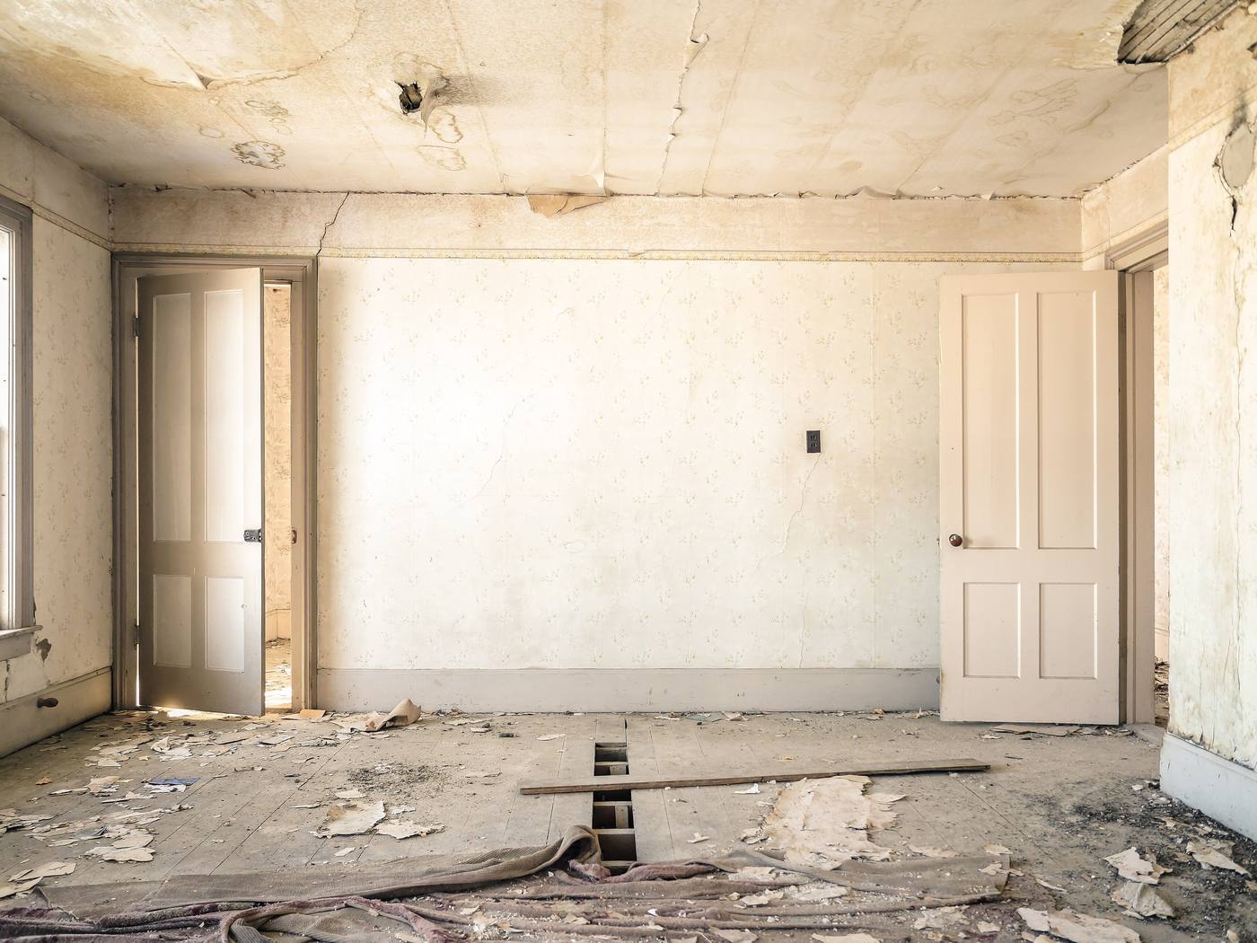
- Ceiling · stainwater stain and hole, approx. 1.5 ftAI suggested
- Ceiling · cracklong crack along board jointAI suggested
- North wall · crackdiagonal, 0.5 mm wide, 10 in longHuman verified
- North wall · hairlinecrack below outlet, under 0.1 mmHuman verified
- East wall · crackvertical, width to be measuredAI suggested
- Floor · boardstwo boards missingAI suggested
{
  "asset": "AP-0412",
  "location": { "lat": 39.9452, "lon": -75.1609 },
  "ceiling": {
    "stain": "water stain and hole, approx. 1.5 ft",
    "crack": "long crack along board joint",
    "status": "ai_suggested"
  },
  "north_wall": {
    "crack": "diagonal, 0.5 mm wide, 10 in long",
    "hairline": "crack below outlet, under 0.1 mm",
    "status": "human_verified"
  },
  "east_wall": {
    "crack": "vertical, width to be measured",
    "status": "ai_suggested"
  },
  "floor": {
    "boards": "two boards missing",
    "status": "ai_suggested"
  },
  "evidence": ["IMG_3318", "IMG_3319", "VN_014"],
  "confidence": 0.88
}
The walk-through is the quick part. The defect log is not.
A surveyor walks every elevation and room of every neighboring property and photographs each existing crack and defect, wide shots and close-ups. Back at the office, every photo is matched to a room and a wall, and every defect is located, described, sized and written into the report.
Multiply that by every property around the site, and the report takes longer than the walk. A thin baseline costs you later: when a neighbor reports new damage, the record has to show what was already there, where it was and how big it was.
- Photoshundreds per property
- Video walkthroughsroom by room
- Crack widths and noteson paper or in voice memos
- Addresses and roomsin separate places
How it works
One workflow from the walk-through to the baseline report. AI drafts the defect log; your surveyor makes the call.
-
Capture offline, room by room
The field app lists the properties around the site and walks the surveyor through each one: elevations from the street, then room by room, wall, ceiling and floor. Every photo, clip and voice note is stamped with time, GPS, property and room. No signal needed in a basement.
-
AI drafts the defect log
Evidence is grouped by property, room and surface and turned into draft entries: cracks, plaster damage, water staining, displaced paving, each located, described and linked to its photos. Crack widths come from the surveyor's gauge, spoken or typed; the AI flags any crack that is still missing one.
-
A surveyor approves
The engineer or surveyor checks each entry next to its photos and approves, edits or rejects it. Only approved surveys become the official baseline, and every value shows whether a person verified it.
-
Report and export the baseline
The approved survey goes out as a PDF report, CSV or GeoJSON, or through the API, in your report format: ready to give the owner, attach to the permit application and compare against after the works.
What the pre-construction survey pack records
Building details for every property, then a defect log by elevation, room and surface. Crack widths and lengths are entered by the surveyor; the AI drafts the location, type and description. During early access we map the pack to the report you already deliver.
Building details
Exterior: facade, foundation, sidewalk
Interior: walls, ceilings, floors
Doors and windows
Site
Every defect carries
References and requirements
Capture in the field. Review from any desk.
Field app preview: a map of today's route with markers by inspection status, working offline, with AP-0416 selected and ready to inspect. Web app preview: the Adjacent properties, 12th St excavation project on a map, with geotagged field photos pinned at each site and a sidebar listing each site's review status.
AI creates the inspection record, not just the report
Keep your GIS and asset system. Inspectial automates the inspection-coding layer in front of it, under rules you can trust.
- Agent-ready data, not documents
- The structured dataset is the source of truth, so your GIS, scripts and AI agents read it directly. Reports are generated from approved observations, never written straight from the media.
- Evidence first
- Every observation references the photos, clips or notes behind it. A finding never exists only as an AI sentence.
- A human approves
- AI proposes; a qualified person decides. Inspectial is not an autonomous inspector, and only approved inspections become official records. Every value is tagged with who stands behind it.
- Location is first-class
- Evidence, observations and assets carry coordinates, so the output drops onto a map without cleanup.
- Offline-first
- The full capture flow works with no signal. Data syncs when the connection returns.
- Configurable, not custom-built
- Your checklist, condition codes and report format live in a template we set up with you. Not a new app.
Who it's for
Outputs and integrations
Inspectial feeds the tools you already run. It doesn't ask you to move your asset data anywhere, and because the output is structured, evidence-linked data rather than a document, it also works as input for AI agents and automations.
Works with
- ArcGIS
- QGIS
- PostGIS
- MapLibre
Formats
- GeoJSON
- CSV
- REST API
- Excelplanned
- Shapefileplanned
- GeoPackageplanned
Questions
Something else? Write to pilot@inspectial.com.
Does the AI replace the surveyor or engineer?
No. The AI drafts the defect log from photos and voice notes; a qualified surveyor or licensed engineer approves, edits or rejects every entry. Only approved surveys become the baseline, and every value shows whether a person verified it.
Can it measure crack widths from photos?
No, and it doesn't try. A photo can't measure a crack width to the precision a baseline needs. The surveyor measures with a crack gauge or ruler and speaks or types the reading; the AI attaches it to the right defect and flags any crack that still has no measurement.
Can the report follow our format?
Yes. The pack is a template: the order of elevations and rooms, defect types, required fields and the PDF layout are configuration, not code. During early access we set it up from a report you already deliver.
How does the post-construction comparison work?
The approved pre-construction survey is the baseline. Because every defect in it has a room, a location and photos, the post-construction survey can follow the same rooms and check each entry, and a person records what is new or has changed. There's no automatic change detection: a person compares, and the structured record makes it fast.
What about owner access and privacy?
You arrange access with each owner; Inspectial doesn't contact neighbors. Photos and notes are stored with the survey in your project and reviewed by your team, and the report is generated only from the approved entries.
Does it cover Philadelphia's pre-construction survey requirement?
It helps you produce the survey; the engineer stays responsible for it. Since April 1, 2026, Philadelphia permit applications must include the Preconstruction Survey Summary form. Projects that trigger Philadelphia Code §4-A-3307, for example excavation more than 5 ft below adjacent grade within 10 ft of a neighboring building, need a survey by a licensed professional engineer that documents the location, extent and dimension of visible cracks, with photos of each elevation visible from the public right-of-way. Inspectial records those items building by building.
Does the field app work offline in basements?
Yes. The full capture flow works with no signal, in a basement, a vacant building or a tunnel shaft. Photos, clips and notes sync when the connection returns.
Will the survey hold up in a damage dispute?
We can't promise a legal outcome. What the record gives you: every defect tied to its timestamped, geotagged photos and to its room and wall, and every value tagged as AI suggested, edited or human verified, so you can show what was recorded, where, and who approved it.
Request early access to pre-construction surveys
Culvert inspection is our live pilot, and pre-construction surveys are in early access. We're looking for a few survey teams to shape the pack. Tell us roughly how many properties you survey a year and what your reports look like today.
- Bring a past survey: the photos and the report you delivered.
- We set up a template from your report format and defect types.
- You compare the AI's draft defect log with what your surveyor wrote.
- Approved surveys export as PDF, CSV or GeoJSON, or through the API.