Insurance underwriting and loss control · Early access
Property inspection software that drafts the underwriting survey from your photos.
Photograph the roof, walls, protection and hazards, and talk through what you see. Inspectial's AI drafts construction, occupancy, protection and exposure fields, hazards and recommendations into a structured, photo-linked survey. Your inspector approves every finding, and the data goes to the carrier in the format they ask for.
Capture offline. AI drafts the COPE fields and hazards. Your inspector approves. Deliver CSV, PDF or API data to the carrier.
- Works offline
- Every finding linked to its photo
- Your inspector approves
- CSV, PDF, GeoJSON, API
Every survey photo becomes a structured finding the underwriter can trust.
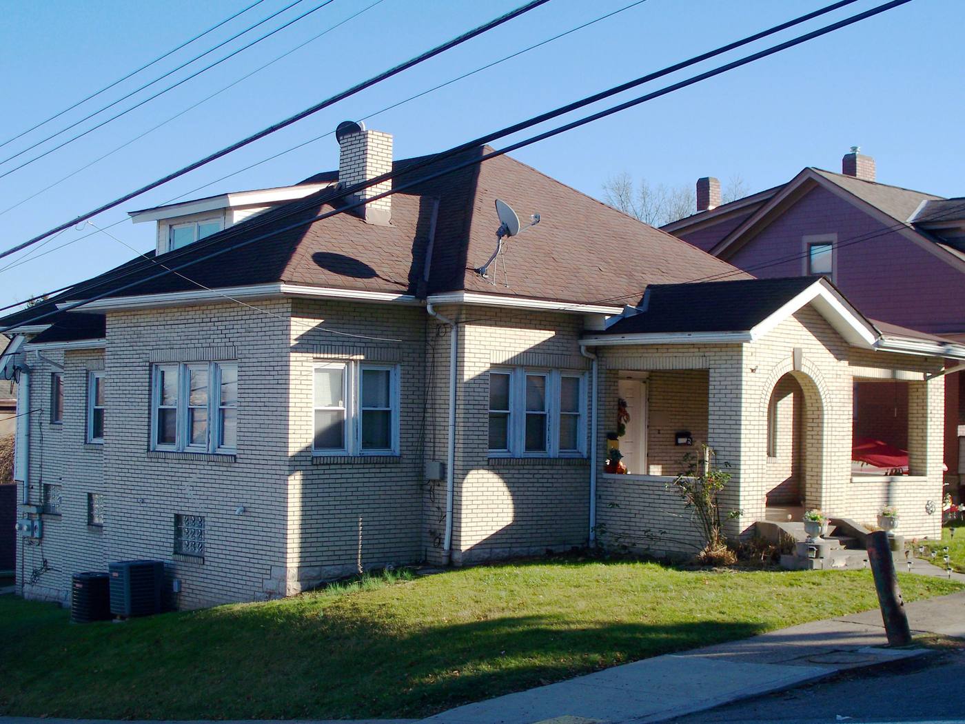
- Roof · coveringasphalt shingle, hipHuman verified
- Roof · conditionno missing or lifted shingles visibleHuman verified
- Chimney · conditionbrick, satellite dish mounted on stackAI suggested
- Service lines · clearanceoverhead lines cross above roof (possible)AI suggested
- Exterior walls · constructionbrick masonryHuman verified
- Porch steps · handrailnone visibleAI suggested
{
  "asset": "PR-2208",
  "location": { "lat": 40.3962, "lon": -80.0418 },
  "roof": {
    "covering": "asphalt shingle, hip",
    "condition": "no missing or lifted shingles visible",
    "status": "human_verified"
  },
  "chimney": {
    "condition": "brick, satellite dish mounted on stack",
    "status": "ai_suggested"
  },
  "service_lines": {
    "clearance": "overhead lines cross above roof (possible)",
    "status": "ai_suggested"
  },
  "exterior_walls": {
    "construction": "brick masonry",
    "status": "human_verified"
  },
  "porch_steps": {
    "handrail": "none visible",
    "status": "ai_suggested"
  },
  "evidence": ["IMG_2208", "IMG_2211", "VN_0031"],
  "confidence": 0.84
}
The site visit is the quick part. Typing up the survey is not.
An inspector comes back from one property with dozens of photos and a few voice notes. Then the survey gets typed: construction, occupancy, protection and exposure, roof covering and condition, hazards and liability items, and the recommendations, each matched to the right photo and the carrier's form.
Across a week of underwriting surveys, that write-up limits how many properties an inspector can take on. And because every inspector describes things a little differently, the underwriter gets surveys that are hard to compare from one property to the next.
- Photosdozens per property
- Voice and text notesunstructured
- The carrier's survey formdifferent for each client
- Address, GPS and order detailsin separate places
How it works
One workflow from the site visit to the underwriter. AI drafts the survey; the inspector makes the call.
-
Capture offline, section by section
The field app lists today's inspections and walks the inspector through your checklist: exterior and construction, roof, occupancy, protection, exposures, hazards and, for a full survey, the interior. Every photo, clip and voice note is stamped with time, GPS and the inspection ID. No signal needed.
-
AI drafts the survey
Evidence is grouped by section and turned into draft fields and findings: construction type, roof covering and condition, protection features, hazards and suggested recommendations, each with a confidence and the photos it came from. Where a photo can't support a value, the field stays blank.
-
The inspector approves
The inspector, or a reviewer on your team, checks each finding next to its photos and approves, edits or rejects it. The AI's suggestion is kept separately from the approved value, so you can always see what a person changed.
-
Deliver in the carrier's format
The approved survey becomes the PDF report and goes out as CSV, GeoJSON or through the API, mapped to the carrier's field names and keyed to their policy or order number. Every property carries coordinates for portfolio and exposure maps.
What the property inspection pack records
COPE plus roof, hazards and recommendations: the sections an underwriting or loss-control survey is built from. In early access we map the template to your clients' survey forms, field names and recommendation wording.
Construction
Occupancy
Protection
Exposure
Roof
Hazards and liability
Recommendations
Recommendation priority
- No action
- Acceptable as found. Nothing to recommend.
- Advisory
- A suggested improvement. The insured is encouraged to act, but it doesn't affect eligibility on its own.
- Required
- Must be corrected by a deadline, for example a missing handrail or a damaged roof covering.
- Urgent
- A serious hazard the underwriter should see right away, such as an active leak or exposed live wiring.
Survey frameworks
Capture in the field. Review from any desk.
Field app preview: a map of today's route with markers by inspection status, working offline, with PR-2212 selected and ready to inspect. Web app preview: the Underwriting, week 41 project on a map, with geotagged field photos pinned at each site and a sidebar listing each site's review status.
AI creates the inspection record, not just the report
Keep your carrier's forms and your delivery process. Inspectial drafts the survey data in front of them, under rules you can trust.
- Agent-ready data, not documents
- The structured dataset is the source of truth, so your GIS, scripts and AI agents read it directly. Reports are generated from approved observations, never written straight from the media.
- Evidence first
- Every observation references the photos, clips or notes behind it. A finding never exists only as an AI sentence.
- A human approves
- AI proposes; a qualified person decides. Inspectial is not an autonomous inspector, and only approved inspections become official records. Every value is tagged with who stands behind it.
- Location is first-class
- Evidence, observations and assets carry coordinates, so the output drops onto a map without cleanup.
- Offline-first
- The full capture flow works with no signal. Data syncs when the connection returns.
- Configurable, not custom-built
- Your checklist, condition codes and report format live in a template we set up with you. Not a new app.
Who it's for
Outputs and integrations
Inspectial feeds the tools you already run. It doesn't ask you to move your asset data anywhere, and because the output is structured, evidence-linked data rather than a document, it also works as input for AI agents and automations.
Works with
- Your carrier's format (CSV or API)
- Excel and CSV
- PDF reports
- GIS and exposure maps
Formats
- GeoJSON
- CSV
- REST API
- Excelplanned
- Shapefileplanned
- GeoPackageplanned
Questions
Something else? Write to pilot@inspectial.com.
Does the AI replace the inspector?
No. AI drafts the survey fields and findings; a qualified inspector approves, edits or rejects each one. Only approved inspections become official, and every value shows whether a person verified it. Inspectial doesn't make underwriting decisions.
Can it follow our carrier clients' survey forms?
Yes. The property pack is a template: sections, fields, hazard types, recommendation wording and the PDF layout are configuration, not code. In early access we set it up with you against the forms your clients use.
What is COPE, and does Inspectial capture it?
COPE stands for construction, occupancy, protection and exposure, the four areas an underwriter uses to judge a property risk. The pack drafts each one from the photos and voice notes, for example wall material, use of the building, sprinklers or hydrant distance, and nearby exposures, and the inspector confirms them.
What about people, house numbers and licence plates in the photos?
Photos are evidence for the inspection you were hired to do, and the AI's findings describe the property, not the people around it. The checklist can remind inspectors to frame out people, house numbers and plates where the carrier doesn't need them.
How fast is the turnaround?
We don't publish speed claims before we have measured them with early-access teams. The aim is simple: the draft survey is ready when the inspector finishes the visit, so they review and approve instead of typing.
How does the data get to the carrier?
Approved surveys export as a PDF report rendered from the approved data, as CSV mapped to the carrier's field names, as GeoJSON, or through the REST API. Excel is planned. There are no direct integrations with carrier platforms yet; CSV and the API are the way in.
Does the field app work without signal?
Yes. The full capture flow works offline, in a rural area or a basement. Photos, clips and voice notes sync when the connection returns.
Is this for home inspections or move-in checks?
No. This pack is built for insurance surveys ordered by carriers and MGAs: underwriting, high-value home and commercial loss-control inspections. A buyer's home inspection or a rental move-in report is a different job with a different audience.
Request early access to the property inspection pack
The property inspection pack is in early access while our culvert pilot runs. We're looking for a few inspection vendors and loss-control teams to shape it. Tell us what you inspect, roughly how many inspections a month, and how you deliver to carriers.
- Bring past inspections: field photos and the surveys you delivered from them.
- We set up a template that matches your clients' forms and recommendation wording.
- You review the AI's draft survey against your inspectors' findings.
- Approved data arrives as a PDF report, CSV or GeoJSON, or through the API, in the carrier's format.