Construction stormwater · Early access
SWPPP inspection app that drafts the report from your site photos.
Photograph each BMP and talk through what you see. Inspectial's AI drafts a BMP-by-BMP record of silt fence, inlet protection, construction exits, stabilization and discharge points, with every maintenance item and corrective action tied to a location and a photo. A qualified inspector approves each finding before anything becomes official.
Capture offline. AI drafts each finding. The inspector approves. Export a PDF report, CSV or GeoJSON.
- Works offline on site
- Every finding linked to its photo
- A qualified inspector approves
- PDF, CSV, GeoJSON, API
Every site photo becomes a BMP-by-BMP record your inspector signs off.
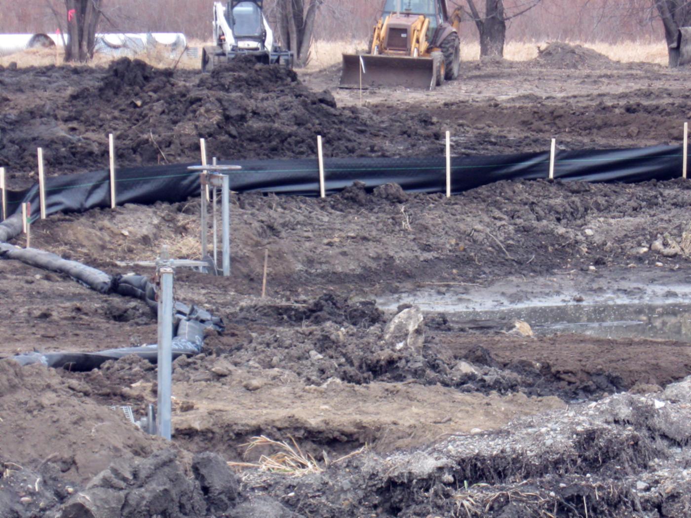
- Stockpile · coveruncoveredAI suggested
- Silt fence · conditionfabric intact, posts uprightHuman verified
- Silt fence · sedimentbelow ½ fence heightHuman verified
- Filter sock · conditiondisplaced, re-set and stakeAI suggested
- Ponded water · clarityturbid (possible)AI suggested
- Disturbed area · stabilizationbare soil, not yet stabilizedHuman verified
{
  "asset": "S-0127",
  "location": { "lat": 30.5127, "lon": -97.6842 },
  "stockpile": {
    "cover": "uncovered",
    "status": "ai_suggested"
  },
  "silt_fence": {
    "condition": "fabric intact, posts upright",
    "sediment": "below ½ fence height",
    "status": "human_verified"
  },
  "filter_sock": {
    "condition": "displaced, re-set and stake",
    "status": "ai_suggested"
  },
  "ponded_water": {
    "clarity": "turbid (possible)",
    "status": "ai_suggested"
  },
  "disturbed_area": {
    "stabilization": "bare soil, not yet stabilized",
    "status": "human_verified"
  },
  "evidence": ["IMG_2207", "IMG_2209", "VN_031"],
  "confidence": 0.88
}Walking the site is the quick part. Writing it up is not.
Under the EPA permit, every active site gets an inspection at least every 7 days, or every 14 days plus within 24 hours of a 0.25-inch storm, and the report is due within 24 hours. Each visit comes back as photos on a phone, marks on the SWPPP map and notes on a form that someone types up.
Across dozens of active sites a week, findings get retyped, photos get matched to BMPs from memory, and a corrective action noted on Tuesday's form can slip out of next week's report.
- PhotosBMPs and discharge points
- Field noteson a clipboard or a phone
- The SWPPP mapproblems marked by hand
- Last week's findingsin another file
How it works
One workflow from the site walk to a report the inspector signs. AI drafts the findings; people make the call.
-
Capture offline, BMP by BMP
The field app lists the sites on today's route and walks the inspector through each site's BMPs: perimeter controls, inlets, the construction exit, stabilization, materials areas and discharge points. Every photo and voice note is stamped with time, GPS and BMP ID. No signal needed.
-
AI drafts the findings
Evidence is grouped by BMP and turned into draft findings: control type, condition, routine maintenance or corrective action, location and the photos behind it, each with a confidence. Photos that don't show enough are marked not assessable instead of guessed.
-
A qualified inspector approves
The inspector checks each finding next to its photos and approves, edits or rejects it. The AI's draft is kept separately from the approved value, so you can always see what a person changed.
-
Report from the approved record
Approved inspections go out as a PDF inspection report, CSV, GeoJSON or through the API, with each problem listed by BMP, location and photo. The report is then signed and certified as your permit requires.
What the SWPPP pack records
Six BMP groups, 31 observation types and a four-step result that follows the permit's own split between routine maintenance and corrective action. During early access we map it to your state's permit, your BMP names and your inspection form.
Perimeter and sediment controls
Inlet protection
Construction exit and track-out
Stabilization
Materials and waste
Discharge points
BMP result
- Effective
- Installed, operational and working as intended.
- Maintenance needed
- Routine upkeep such as removing sediment, re-staking or cleaning. The EPA permit expects it done by the close of the next business day.
- Corrective action
- Significant repair, a new or replacement control, or the same fix needed three or more times. Under the EPA permit: logged within 24 hours, fixed within 7 calendar days.
- Missing or failed
- A required control was never installed, was removed early or has failed outright. Listed first in the report.
Permits and forms
Capture in the field. Review from any desk.
Field app preview: a map of today's route with markers by inspection status, working offline, with S-0142 selected and ready to inspect. Web app preview: the Weekly SWPPP route project on a map, with geotagged field photos pinned at each site and a sidebar listing each site's review status.
AI creates the inspection record, not just the report
Keep your GIS and asset system. Inspectial automates the inspection-coding layer in front of it, under rules you can trust.
- Agent-ready data, not documents
- The structured dataset is the source of truth, so your GIS, scripts and AI agents read it directly. Reports are generated from approved observations, never written straight from the media.
- Evidence first
- Every observation references the photos, clips or notes behind it. A finding never exists only as an AI sentence.
- A human approves
- AI proposes; a qualified person decides. Inspectial is not an autonomous inspector, and only approved inspections become official records. Every value is tagged with who stands behind it.
- Location is first-class
- Evidence, observations and assets carry coordinates, so the output drops onto a map without cleanup.
- Offline-first
- The full capture flow works with no signal. Data syncs when the connection returns.
- Configurable, not custom-built
- Your checklist, condition codes and report format live in a template we set up with you. Not a new app.
Who it's for
Outputs and integrations
Inspectial feeds the tools you already run. It doesn't ask you to move your asset data anywhere, and because the output is structured, evidence-linked data rather than a document, it also works as input for AI agents and automations.
Works with
- ArcGIS
- QGIS
- PostGIS
- MapLibre
Formats
- GeoJSON
- CSV
- REST API
- Excelplanned
- Shapefileplanned
- GeoPackageplanned
Questions
Something else? Write to pilot@inspectial.com.
Does the AI replace the qualified inspector?
No. Your permit requires a qualified person to inspect the site, and that doesn't change. Inspectial drafts findings from the inspector's photos and notes; the inspector approves, edits or rejects each one. Only approved inspections become official, and every value shows whether a person verified it.
Can it follow our state's permit and inspection form?
Yes. The SWPPP pack is a template: the BMP list, observation types, result scale and report layout are configuration, not code. During early access we set it up for your state's construction general permit and the inspection form you already use.
Does it handle rain-event inspections?
You run a rain-event inspection the same way as a weekly one and record the rainfall reading in it. Inspectial doesn't watch rain gauges or weather stations and doesn't remind you when an inspection is due, so keep your current trigger for that.
How are corrective actions tracked?
Each problem is a finding with the BMP, its GPS location, the photos and whether it needs routine maintenance or corrective action. The next inspection uses the same BMP list, so you can see whether it was fixed. Inspectial doesn't replace your corrective action log yet, but it gives you the entries for it.
Who signs the inspection report?
The same person as today. The PDF report is produced from the approved record, then signed and certified as your permit requires (under the EPA permit, by the operator's signatory). Inspectial doesn't do e-signatures and doesn't file anything with EPA or your state.
Does the field app work without signal?
Yes. The full capture flow works offline, on a graded lot with no coverage. Photos and voice notes sync when the connection returns.
Do the photos hold up as evidence?
Every photo and voice note is stamped with time and GPS at capture, and every finding links to the evidence behind it. That matters where photos are required, such as dewatering inspections and the dated photos for a Notice of Termination under the 2022 EPA permit.
Can we start with past inspections?
Yes, that's how early access starts: bring site photos and the reports your inspectors wrote from them, and we compare the AI's draft findings with theirs.
Request early access to the SWPPP pack
We're setting up the SWPPP template with a small number of stormwater inspection teams. Tell us roughly how many sites you inspect a week, which permit you work under and the form you report on.
- Bring real inspections: site photos and the reports you wrote from them.
- We set up a SWPPP template that matches your BMP list and inspection form.
- You review the AI's draft findings against your inspectors' own.
- Reports arrive as PDF, with the data as CSV or GeoJSON, or through the API.