Disaster damage assessment · Early access
Damage assessment software that drafts every site record for you.
After a storm, flood or fire, photograph each damaged road, culvert, bridge, building or park. Inspectial's AI drafts a geolocated damage record for every site: category of work, damage type, description and severity, each linked to the photos and voice notes behind it. Your assessor approves every finding, and the data goes to your damage inventory and GIS instead of a camera roll.
Capture offline when networks are down. AI drafts each site. An assessor approves. Export for the PDA, PA and your GIS.
- Works offline
- Every finding linked to its photo
- A qualified assessor approves
- GeoJSON, CSV, PDF, API
Every damaged site becomes a record your assessor can review.
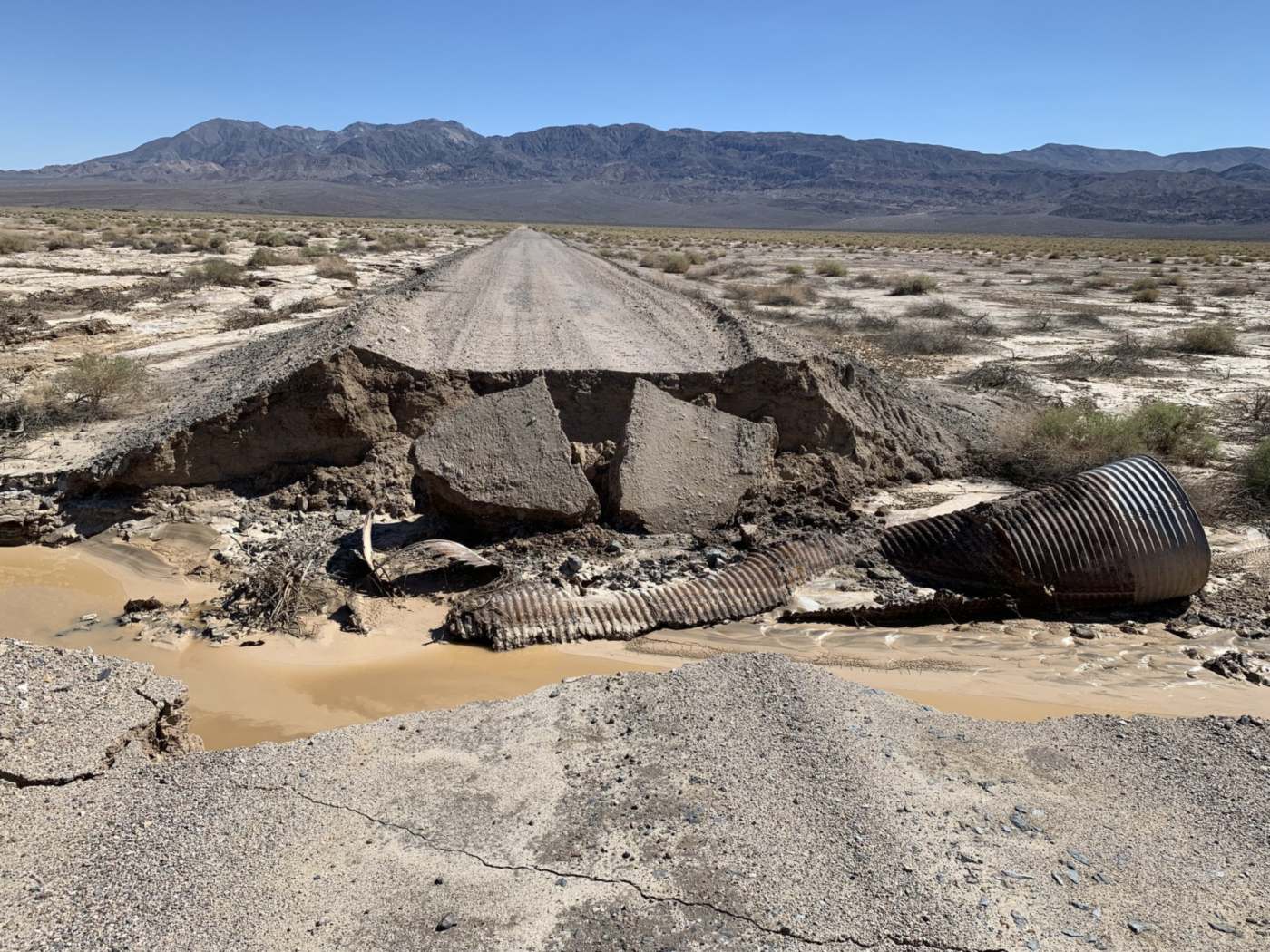
- Road · washoutfull roadway width, Cat. CHuman verified
- Road · pavementslabs displaced into gapHuman verified
- Culvert · positionwashed out of the fillAI suggested
- Culvert · barrelcrushed and tornAI suggested
- Channel · sedimentdeposit across roadwayAI suggested
- Debris · typewoody, small volume (possible)AI suggested
{
  "asset": "DS-0217",
  "location": { "lat": 34.8462, "lon": -116.2185 },
  "road": {
    "washout": "full roadway width, Cat. C",
    "pavement": "slabs displaced into gap",
    "status": "human_verified"
  },
  "culvert": {
    "position": "washed out of the fill",
    "barrel": "crushed and torn",
    "status": "ai_suggested"
  },
  "channel": {
    "sediment": "deposit across roadway",
    "status": "ai_suggested"
  },
  "debris": {
    "type": "woody, small volume (possible)",
    "status": "ai_suggested"
  },
  "evidence": ["IMG_3318", "IMG_3321", "VOICE_014"],
  "confidence": 0.87
}After the storm, teams fan out. The write-up lands on one desk.
Damage assessment crews come back with hundreds of phone photos, voice memos, texts and addresses. Someone then builds the site list, matches photos to locations, writes a damage description for each site, assigns the category of work and assembles the photo log, while the state and FEMA wait for numbers.
For Public Assistance, the deadline keeps running: applicants have 60 days from the Recovery Scoping Meeting to report all disaster-related impacts to FEMA. Damage that wasn't documented well in the field is hard to document later.
- Photos5 to 30 per site, from many phones
- Voice memos and textsdamage described in passing
- Locationsaddresses, road names, a pin in a chat
- Pre-disaster recordsinspections and maintenance logs, filed elsewhere
How it works
One workflow from the field to your damage inventory and GIS. AI drafts the descriptions; your assessors make the call.
-
Capture offline, site by site
The field app shows the sites to assess on a map and walks each team through a short checklist: overview, damage, dimensions, debris. Every photo, clip and voice note is stamped with time, GPS and site ID. It works with no signal, which matters when towers are down.
-
AI drafts the damage record
Evidence is grouped by site and turned into draft observations: category of work, damage type, a short damage description, a severity level, a confidence and the photos it came from. Where the photos don't show enough, the AI marks it not assessable instead of guessing.
-
An assessor approves
A qualified assessor checks each finding next to its photos and approves, edits or rejects it. Dimensions come from the field team's measurements, not from the AI. The draft is kept separately from the approved value, so you can see what a person changed.
-
Export for the PDA, PA and your GIS
Approved sites go out as CSV or GeoJSON with coordinates, categories, descriptions and photo references, or through the API. Use them to fill your state's damage assessment forms and your damage inventory, and to map the event in ArcGIS or QGIS. The PDF photo log is rendered from the same approved data.
What the damage assessment pack records
Findings grouped by FEMA Public Assistance category of work, each with a damage type, a description, a severity, a confidence and the photos behind it. For homes, the damage levels used in preliminary damage assessments. In early access we map the template to your state's forms and your site IDs.
A · Debris removal
B · Emergency protective measures
C · Roads and bridges
D · Water control facilities
E · Public buildings and equipment
F · Public utilities
G · Parks, recreational and other facilities
Damage levels for homes (IA)
- Affected
- Mostly cosmetic damage. The home can still be lived in.
- Minor
- Repairable damage that can make the home livable again in a short time.
- Major
- Significant structural damage that needs extensive repairs.
- Destroyed
- A total loss, or damaged so badly that repair isn't economically feasible.
Reference rules and guidance
Capture in the field. Review from any desk.
Field app preview: a map of today's route with markers by inspection status, working offline, with DS-0230 selected and ready to inspect. Web app preview: the Flood event, Oct 2026 project on a map, with geotagged field photos pinned at each site and a sidebar listing each site's review status.
AI creates the inspection record, not just the report
Keep your GIS and asset system. Inspectial automates the inspection-coding layer in front of it, under rules you can trust.
- Agent-ready data, not documents
- The structured dataset is the source of truth, so your GIS, scripts and AI agents read it directly. Reports are generated from approved observations, never written straight from the media.
- Evidence first
- Every observation references the photos, clips or notes behind it. A finding never exists only as an AI sentence.
- A human approves
- AI proposes; a qualified person decides. Inspectial is not an autonomous inspector, and only approved inspections become official records. Every value is tagged with who stands behind it.
- Location is first-class
- Evidence, observations and assets carry coordinates, so the output drops onto a map without cleanup.
- Offline-first
- The full capture flow works with no signal. Data syncs when the connection returns.
- Configurable, not custom-built
- Your checklist, condition codes and report format live in a template we set up with you. Not a new app.
Who it's for
Outputs and integrations
Inspectial feeds the tools you already run. It doesn't ask you to move your asset data anywhere, and because the output is structured, evidence-linked data rather than a document, it also works as input for AI agents and automations.
Works with
- ArcGIS
- QGIS
- PostGIS
- MapLibre
Formats
- GeoJSON
- CSV
- REST API
- Excelplanned
- Shapefileplanned
- GeoPackageplanned
Questions
Something else? Write to pilot@inspectial.com.
Does the AI replace the damage assessor?
No. Inspectial drafts observations from the evidence your teams capture; it doesn't assess anything on its own. A qualified assessor approves, edits or rejects every finding, and only approved records become official. Every value shows whether a person verified it.
Does it follow FEMA categories and our state's forms?
The template is organised by the Public Assistance categories of work, A to G, and uses Affected, Minor, Major and Destroyed for homes. In early access we map it to your state's damage assessment forms and your site IDs. Inspectial doesn't submit anything to FEMA or the Grants Portal, doesn't write cost estimates or project worksheets, and doesn't decide eligibility: FEMA does.
Does it work when cell networks are down?
Yes. The full capture flow works offline: photos, video clips, voice notes and GPS stay on the phone and sync when a connection returns, whether that's hours later or back at the office.
How quickly can we use it after an event?
The damage assessment pack is in early access and the field app is still in development, so the realistic path is to set it up before your next season. We configure the template, site IDs and export layout with you in advance, so on the day your teams install the app and go.
Can routine inspection data serve as pre-disaster evidence?
It can help. Public Assistance restores facilities to their design as it existed immediately before the disaster (44 CFR 206.226), so dated, geolocated photos of a road, culvert or building taken before the event are useful. Approved inspections from Inspectial's routine packs, such as culverts, are exactly that. FEMA decides what documentation it accepts for each project.
How does the data get into our GIS and PA workflow?
Approved sites export as GeoJSON or CSV with coordinates, categories, descriptions and photo references, or through the REST API. ArcGIS, QGIS and PostGIS read them directly. There's no native connector to other damage assessment tools yet, so in early access we match the export columns to the forms and layers you already use.
Can several teams assess at the same time?
Yes. Each team captures on its own phones against the same event project. As phones sync, the reviewer sees every site on one map with its status: captured, ready for review or approved.
What about photos of private homes and residents?
The template asks assessors to photograph damage, not people, and the AI describes damage only. Evidence belongs to your organisation and is used only to draft your records. In early access we agree in writing where it's stored, who can see it and how long it's kept.
Request early access to the damage assessment pack
We're setting up the damage assessment template with a few emergency management teams, public works departments and recovery consultants, ideally before the next storm season. Tell us what you assess, how many sites a typical event produces, and which GIS you report into.
- Bring photos and notes from a past event, and the site list or damage inventory your team built from them.
- We set up a template with your categories, damage types, site IDs and forms.
- Your assessors review the AI's drafts against what they recorded.
- Exports arrive as CSV, GeoJSON or PDF, or through the API, in the layout your PDA or PA workflow needs.