Utility pole inspection · Early access
Utility pole inspection software that turns crew photos into pole records.
Your crews already photograph every pole. Inspectial reads the pole tag and birthmark where they're legible, drafts defects, attachments and a priority from the photos, and links every value to the photo behind it. A qualified inspector approves each record before it reaches GIS or the utility's system.
Capture offline. AI drafts the pole record. An inspector approves. Export to ArcGIS, QGIS or the utility's system.
- Works offline
- Every finding linked to its photo
- A qualified reviewer approves
- GeoJSON, CSV, PDF, API
Every pole photo becomes a structured record your reviewer can check.
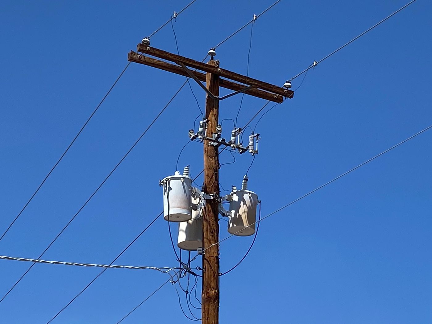
- Crossarm · conditiondouble arm, no visible defectsHuman verified
- Insulator · conditionpin type, no visible damageAI suggested
- Cutouts · conditionno visible damageAI suggested
- Transformers · oil leaknone visibleHuman verified
- Service drop · attachmenttriplex, securedAI suggested
- Pole · surfacechecking (possible)AI suggested
{
  "asset": "P-10443",
  "location": { "lat": 34.4048, "lon": -103.2052 },
  "crossarm": {
    "condition": "double arm, no visible defects",
    "status": "human_verified"
  },
  "insulator": {
    "condition": "pin type, no visible damage",
    "status": "ai_suggested"
  },
  "cutouts": {
    "condition": "no visible damage",
    "status": "ai_suggested"
  },
  "transformers": {
    "oil_leak": "none visible",
    "status": "human_verified"
  },
  "service_drop": {
    "attachment": "triplex, secured",
    "status": "ai_suggested"
  },
  "pole": {
    "surface": "checking (possible)",
    "status": "ai_suggested"
  },
  "evidence": ["IMG_3307", "IMG_3308"],
  "confidence": 0.89
}Photographing the pole is quick. Re-keying it is not.
Each pole comes back as a set of photos: tag, birthmark, pole top, ground line, attachments. Someone in the office then reads the tag, types class, length, treatment year and species from the birthmark, codes each defect, counts attachments, assigns a priority and enters it all into the utility's system.
Across a feeder of several hundred poles, that data entry is the slow part of the job and the place where typos creep in. What the utility gets is often a spreadsheet that someone has to load again.
- Photostag, birthmark, top, ground line
- Voice notessound and bore results
- Attachmentsowner, count, height
- GPS and the pole IDmatched by hand
How it works
One workflow from the pole to the utility's system. AI drafts the record; a qualified inspector makes the call.
-
Capture offline, pole by pole
The field app lists today's poles by distance and walks the crew through the checklist: tag, birthmark, pole top, body, ground line, guys and attachments. Every photo and voice note is stamped with time, GPS and pole ID. No signal needed.
-
AI drafts the pole record
Photos are grouped by component and turned into observations: tag number and birthmark values where legible, crossarm and hardware condition, woodpecker damage, lean, guys and attachments, each with a confidence and the photos behind it.
-
An inspector approves
A qualified reviewer checks each finding next to its photos, approves, edits or rejects it, and sets the final priority. Sound and bore results come from the inspector. The AI's suggestion is kept beside the approved value, so you can see what a person changed.
-
Export to the utility's system
Approved pole records go out as GeoJSON, CSV, a PDF report or through the API, keyed to the utility's pole numbers and ready for ArcGIS, QGIS or the client's asset system.
What the utility pole pack records
Six components, the observations pole crews code most often, and a reject scale. Sound, bore and shell readings are entered by the inspector. During early access we map the template to your client's reject codes, pole numbering and attachment fields.
Pole top, crossarm and hardware
Pole body
Ground line
Guys and anchors
Attachments and joint use
Clearances and vegetation
Reject and priority codes
- Pass
- No reject criteria found. Recorded with photos for the next cycle.
- Maintenance
- The pole is serviceable, but an item needs follow-up: a slack guy, a missing guy guard, loose hardware or vegetation.
- Restorable reject
- Fails the strength criteria but can be reinforced or treated instead of replaced.
- Reject
- Replace on the utility's normal reject schedule.
- Priority reject
- Immediate risk to the public, workers or the circuit. Make safe and replace first.
Reference standards
Capture in the field. Review from any desk.
Field app preview: a map of today's route with markers by inspection status, working offline, with P-10447 selected and ready to inspect. Web app preview: the Feeder 14 pole audit project on a map, with geotagged field photos pinned at each site and a sidebar listing each site's review status.
AI creates the inspection record, not just the report
Keep your GIS and asset system. Inspectial automates the inspection-coding layer in front of it, under rules you can trust.
- Agent-ready data, not documents
- The structured dataset is the source of truth, so your GIS, scripts and AI agents read it directly. Reports are generated from approved observations, never written straight from the media.
- Evidence first
- Every observation references the photos, clips or notes behind it. A finding never exists only as an AI sentence.
- A human approves
- AI proposes; a qualified person decides. Inspectial is not an autonomous inspector, and only approved inspections become official records. Every value is tagged with who stands behind it.
- Location is first-class
- Evidence, observations and assets carry coordinates, so the output drops onto a map without cleanup.
- Offline-first
- The full capture flow works with no signal. Data syncs when the connection returns.
- Configurable, not custom-built
- Your checklist, condition codes and report format live in a template we set up with you. Not a new app.
Who it's for
Outputs and integrations
Inspectial feeds the tools you already run. It doesn't ask you to move your asset data anywhere, and because the output is structured, evidence-linked data rather than a document, it also works as input for AI agents and automations.
Works with
- ArcGIS
- QGIS
- PostGIS
- MapLibre
Formats
- GeoJSON
- CSV
- REST API
- Excelplanned
- Shapefileplanned
- GeoPackageplanned
Questions
Something else? Write to pilot@inspectial.com.
Does the AI replace the pole inspector?
No. AI drafts the observations from photos; a qualified inspector approves, edits or rejects each one and sets the final priority. Only approved inspections become official records, and every value shows whether a person verified it.
Can it sound or bore a pole?
No. Sound, bore, excavation and resistance-drilling results come from the inspector, recorded by voice or in the checklist, and are stored next to the photos. The AI handles what the photos show: woodpecker holes, splits, lean, crossarm and hardware condition, guys and attachments.
Can it read pole tags and birthmarks?
When the tag or birthmark is legible in the photo, the AI drafts the values: the pole number, and from the birthmark the supplier, treatment year, species, preservative, class and length. Worn or hidden marks are flagged as not readable instead of guessed, and the reviewer confirms every value.
Can it use our client's reject and priority codes?
Yes. The pole pack is a template: components, defect types, reject categories and the report layout are configuration, not code. During early access we set it up with your client's codes, pole numbering and required fields.
Does it handle joint-use attachment counts?
Yes. The template records each attachment with its owner, type and height, plus risers and equipment. The AI drafts the count and attachment types from the photos; heights come from the crew's measurements and owners from tags or the crew's notes. The reviewer confirms all of it.
Does the field app work without signal?
Yes. The full capture flow works offline, on rural feeders and rights-of-way with no coverage. Photos and notes sync when the connection returns.
How does the data get into GIS or the utility's system?
Approved inspections export as GeoJSON or CSV with coordinates and pole IDs, as a PDF report, or through the REST API. ArcGIS, QGIS and PostGIS read them directly. Excel, Shapefile and GeoPackage exports are planned.
Can we start with historical photos?
Yes, that's how early access starts: bring the photos from a completed feeder and the records your team delivered, and we compare the AI's drafts with your inspectors' findings.
Request early access for utility poles
Culverts are our live pilot; the utility pole pack is in early access. We're looking for a small number of pole inspection and joint-use audit teams to shape it. Tell us what you inspect, roughly how many poles a year, and which system your client wants the data in.
- Bring a completed feeder: the photos and the records your team delivered.
- We set up a pole template with your client's reject codes and fields.
- You compare the AI's draft records with your inspectors' findings.
- Exports arrive as GeoJSON, CSV or PDF, or through the API.