Construction QA/QC inspection · Early access
Construction inspection software that drafts the record from your photos.
Photograph the work and talk through what you see. Inspectial's AI drafts a structured inspection record from your photos and voice notes, tied to the station and spec item, with possible non-conformances flagged. Your inspector approves every finding, and the record lands on a map, not in a photo folder.
Capture offline. AI drafts each observation. An inspector approves. Export a PDF report, CSV or GeoJSON.
- Works offline
- Every finding linked to its photo
- A qualified reviewer approves
- GeoJSON, CSV, PDF, API
Every inspection point becomes a located record your team can review.
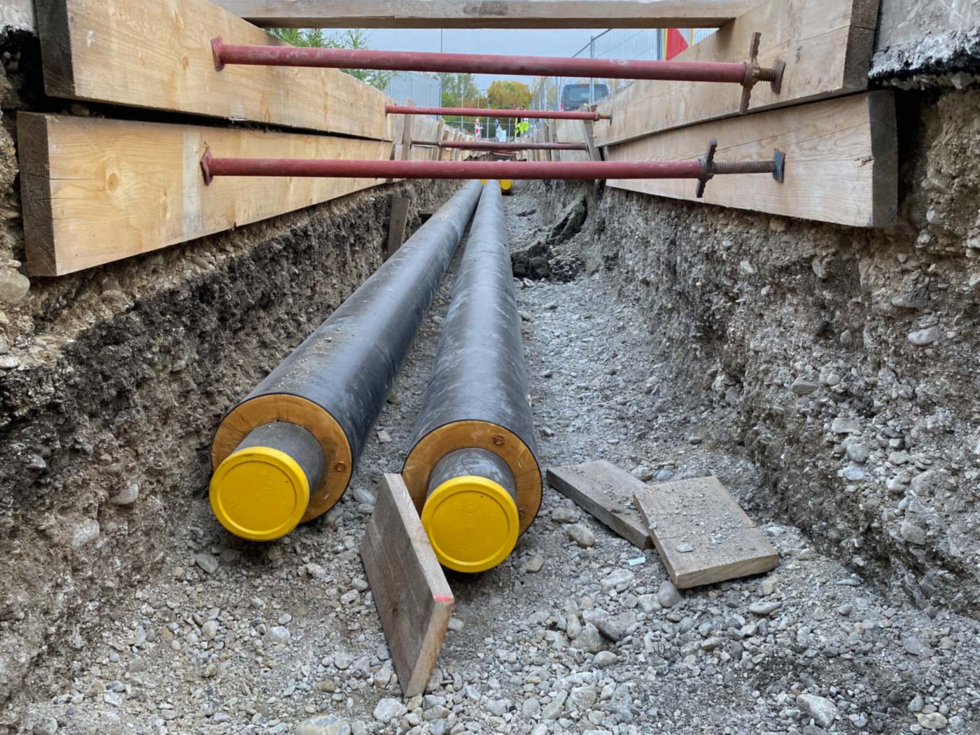
- Trench support · strutsin place, bearing on sheetingHuman verified
- Trench support · sheetingtimber, upper wall onlyHuman verified
- Trench wall · protectionunshored below, check depthAI suggested
- Pipe · jacketno visible damageAI suggested
- Pipe · end capsfitted on both pipesAI suggested
- Trench bottom · debrisloose boards on beddingAI suggested
{
  "asset": "QA-0412",
  "location": { "lat": 40.0418, "lon": -83.0612 },
  "trench_support": {
    "struts": "in place, bearing on sheeting",
    "sheeting": "timber, upper wall only",
    "status": "human_verified"
  },
  "trench_wall": {
    "protection": "unshored below, check depth",
    "status": "ai_suggested"
  },
  "pipe": {
    "jacket": "no visible damage",
    "end_caps": "fitted on both pipes",
    "status": "ai_suggested"
  },
  "trench_bottom": {
    "debris": "loose boards on bedding",
    "status": "ai_suggested"
  },
  "evidence": ["IMG_2207", "IMG_2208", "VN_031"],
  "confidence": 0.86
}
The inspection takes an hour. The write-up takes the evening.
A construction inspector comes back from site with hundreds of photos a week, a notebook and a list of follow-ups. Then the writing starts: the daily inspection report, the non-conformance reports, the punch items, every photo renamed and matched to a station, a spec section and a line in the inspection and test plan.
Owners and agencies want that evidence tied to locations and approved by a named inspector. What they usually get is a PDF and a shared folder of loose photos that nobody can search a year later.
- Photoshundreds per week
- Voice and field notesunstructured
- ITP, specs and drawingsin another binder
- Stations and GPSin separate places
How it works
One workflow from the photo to the inspection record. AI drafts the findings; your inspector makes the call.
-
Capture offline, point by point
The field app lists today's inspection points with their station, work item, spec section and ITP checklist. Every photo, clip and voice note is stamped with time, GPS and the inspection point. No signal needed in a trench or a cut.
-
AI drafts the observations
Evidence is grouped by work item and turned into structured observations: what was checked, what the photos show and whether it appears to conform, each with a confidence and the photos it came from. Checks that need a measurement are flagged for the inspector, not guessed.
-
An inspector approves
A qualified inspector reviews each finding next to its photos and approves, edits or rejects it. A flagged non-conformance becomes an NCR only when a person confirms it, and the AI's draft is kept separate from the approved record.
-
Report and export
Approved records go out as a PDF report, CSV or GeoJSON, or through the API, keyed to your project, stations and spec sections and ready for your document control system or GIS.
What the construction QA pack records
Work items, observation types and a result scale that follow how QA inspectors already write. Items marked measured are entered by the inspector; the AI only flags that a measurement is due. During early access we map the pack to your ITP, forms and spec sections.
Earthwork and subgrade
Pipe and utilities
Concrete and reinforcement
Paving
Site and as-built
Result scale
- Conforms
- Work matches the drawings, specifications and ITP criteria for this check.
- Observation
- Minor issue or something to watch. Recorded and followed up, no formal NCR.
- Nonconforming
- Non-conformance (NCR): work doesn't meet the specification or drawings. Needs a disposition: rework, repair or use as is.
- Hold
- Work stops at this point until the responsible party inspects and releases it.
Reference standards
Capture in the field. Review from any desk.
Field app preview: a map of today's route with markers by inspection status, working offline, with QA-0416 selected and ready to inspect. Web app preview: the Utility corridor, Phase 2 project on a map, with geotagged field photos pinned at each site and a sidebar listing each site's review status.
AI creates the inspection record, not just the report
Keep your GIS and asset system. Inspectial automates the inspection-coding layer in front of it, under rules you can trust.
- Agent-ready data, not documents
- The structured dataset is the source of truth, so your GIS, scripts and AI agents read it directly. Reports are generated from approved observations, never written straight from the media.
- Evidence first
- Every observation references the photos, clips or notes behind it. A finding never exists only as an AI sentence.
- A human approves
- AI proposes; a qualified person decides. Inspectial is not an autonomous inspector, and only approved inspections become official records. Every value is tagged with who stands behind it.
- Location is first-class
- Evidence, observations and assets carry coordinates, so the output drops onto a map without cleanup.
- Offline-first
- The full capture flow works with no signal. Data syncs when the connection returns.
- Configurable, not custom-built
- Your checklist, condition codes and report format live in a template we set up with you. Not a new app.
Who it's for
Outputs and integrations
Inspectial feeds the tools you already run. It doesn't ask you to move your asset data anywhere, and because the output is structured, evidence-linked data rather than a document, it also works as input for AI agents and automations.
Works with
- ArcGIS
- QGIS
- PostGIS
- MapLibre
Formats
- GeoJSON
- CSV
- REST API
- Excelplanned
- Shapefileplanned
- GeoPackageplanned
Questions
Something else? Write to pilot@inspectial.com.
Does the AI replace the inspector?
No. AI drafts observations from the photos and notes; a qualified inspector approves, edits or rejects each one. Only approved inspections become official records, every value shows whether a person verified it, and the inspector of record stays the inspector of record.
Can it follow our ITP and inspection forms?
Yes. The construction pack is a template: work items, checklists, hold and witness points, the result scale and the report layout are configuration, not code. During early access we set it up from your ITP and the forms you already use.
Can it check rebar spacing or cover from a photo?
No, and it doesn't pretend to. A photo can't verify a dimension to the tolerance your specification sets. The inspector records measurements and test results; the AI drafts what the photos show and flags the checks that still need a tape, a gauge or a test.
How does it handle NCRs and punch lists?
When the AI sees something that may not conform, it flags it with the photos attached. The inspector decides whether it becomes a non-conformance, an observation or nothing. Punch items are recorded the same way, each with its photo and location. Approved items export as a CSV log or PDF, or through the API.
We already use Procore or Autodesk Build. Why add this?
Inspectial isn't project management, scheduling, RFIs or drawing management, and it doesn't replace those tools. It does one job: turning field evidence into an approved, located inspection record. The approved data exports as PDF, CSV or GeoJSON, or through the API, so it sits next to the platform you already run.
How do stations and locations work?
Every photo carries GPS from the phone, and each inspection point carries the station, offset and spec section from your project setup. Reviewers see findings on a map, and exports keep both coordinates and stationing. Phone GPS is good to a few metres: enough to find a point again, but not a survey.
Does the field app work without signal?
Yes. The full capture flow works offline, in a trench, a cut or a rural corridor. Photos, clips and notes sync when the connection returns.
Can we start with past projects?
Yes, that's how early access starts: bring photos and the daily reports or NCRs your inspectors wrote from them, and we compare the AI's draft with what your team actually recorded.
Request early access to construction QA
Culvert inspection is our live pilot, and construction QA is next. We're looking for a few inspection teams to shape it. Tell us what you inspect, roughly how many inspections a year, and where your reports go today.
- Bring real inspections: photos, notes and the reports you wrote from them.
- We set up a template from your ITP, forms and result scale.
- You compare the AI's draft records with your inspectors' findings.
- Approved records export as PDF, CSV or GeoJSON, or through the API.